Despite
my love/hate relationship with New Year's resolutions, I've always found it interesting - and sometimes inspiring and motivating - to look back and see what I've accomplished on the layout during the previous 12 months. Those posts tend to be mostly lists of what I'd hoped I'd accomplish, what I actually accomplished, and what I hope to accomplish in the coming year.
But how about something a lot more visual? See where things were at the beginning of the previous year and where they are today? I
really wish I'd thought to do this all along - especially during the
huge build-out of the layout that occurred over an 18-month period
from February 2015 through the summer of 2016. Comparing before and after photos from that time shows a
lot of dramatic progress as I doubled the size of the layout, adding the Shoreline and the line from Old Saybrook all the way up to Middletown(!)
So first, here are some photos taken near the beginning of 2019 (and I'll follow-up with a complete photo tour of the layout's status as of this week).
 |
| Valley Coal - just track and a couple of structures. |
 |
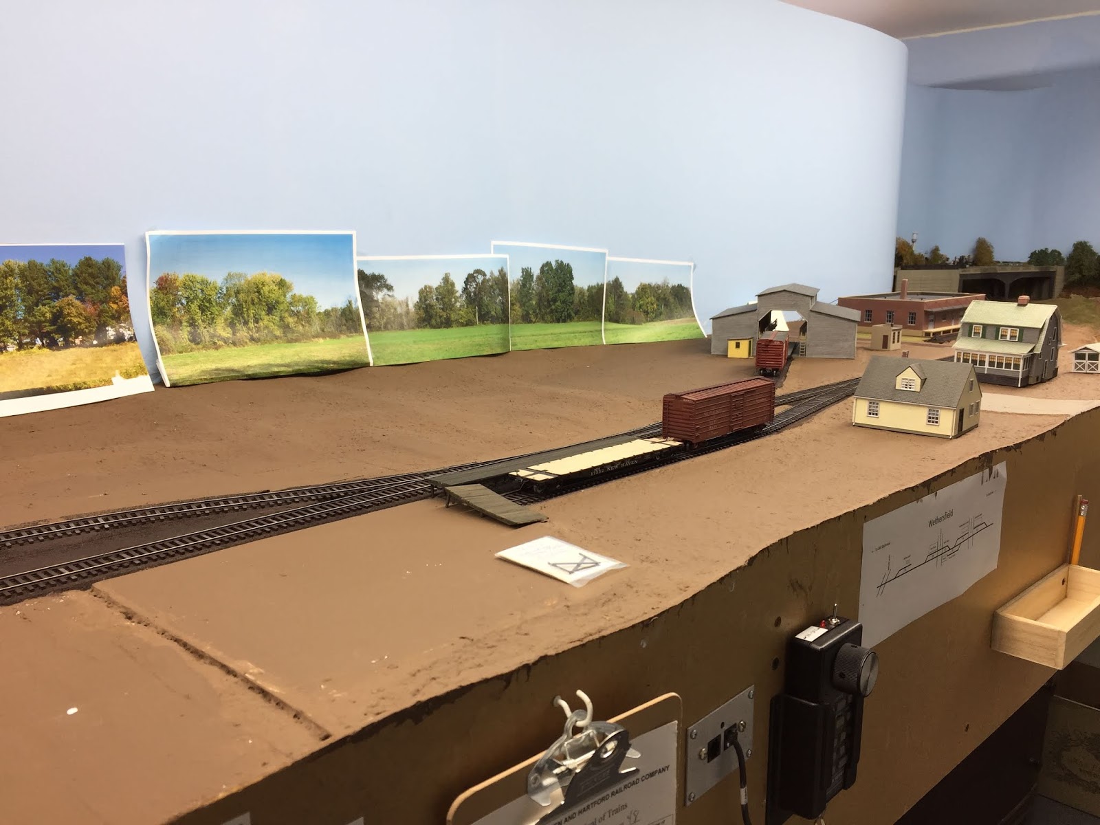
| Wethersfield - Cape Cod house done, but John's house is still a mockup. |
 |
| Looking south toward Church Street from Jordan Lane. Gra-Rock is just a mockup. |
 |
| I'd just started laying additional foundation (plywood) for the Rt. 15 overpass and decided to redo some of the terrain in the process. |
 |
| Essex, looking north |
 |
| East Berlin |
 |
| Deep River, looking north |
And here's where things are as of today - you'll see some familiar scenes, some of which have changed a lot for the better! There are a lot of photos, but they cover the whole layout (except staging) and will provide a nice baseline for when I do this comparison this time next year.
Don't forget, you can always click on a photo for a larger view. And for more information on any particular area, be sure to check out the "Topics" list on the right side of the page.
 |
| End of the Berlin Branch at East Berlin, CT. All major structures in as well as backdrop & base scenery |
 |
| Panning left, we see the Rt. 15 overpass and part of Wethersfield. |
 |
| Wethersfield, including John Wallace's house completed. |
 |
| Panning left and looking south toward Valley Coal. Gra-Rock building is done and waiting for surrounding scenery. |
 |
| Valley Coal - some base scenery is in, but still need to do the backdrop. |
 |
| Goff Brook area of Rocky Hill, just south of the Wethersfield line. With the pouring of the water, this scene is definitely at a level of "done-ness" |
 |
| Continuing south around the end of the peninsula, we come into the Rocky Hill station area, which was one of the first areas to get full treatment (except for backdrop). |
 |
| South of Rocky Hill is the section of town known as Dividend - notable for the huge Hartford Rayon plant & largest customer on the line. The major buildings are done (thanks to Dave Messer) and I've reworked the topography here to level things out a bit (using foam board rather than repeat the debacle of troweling on more Ground Goop!) |
 |
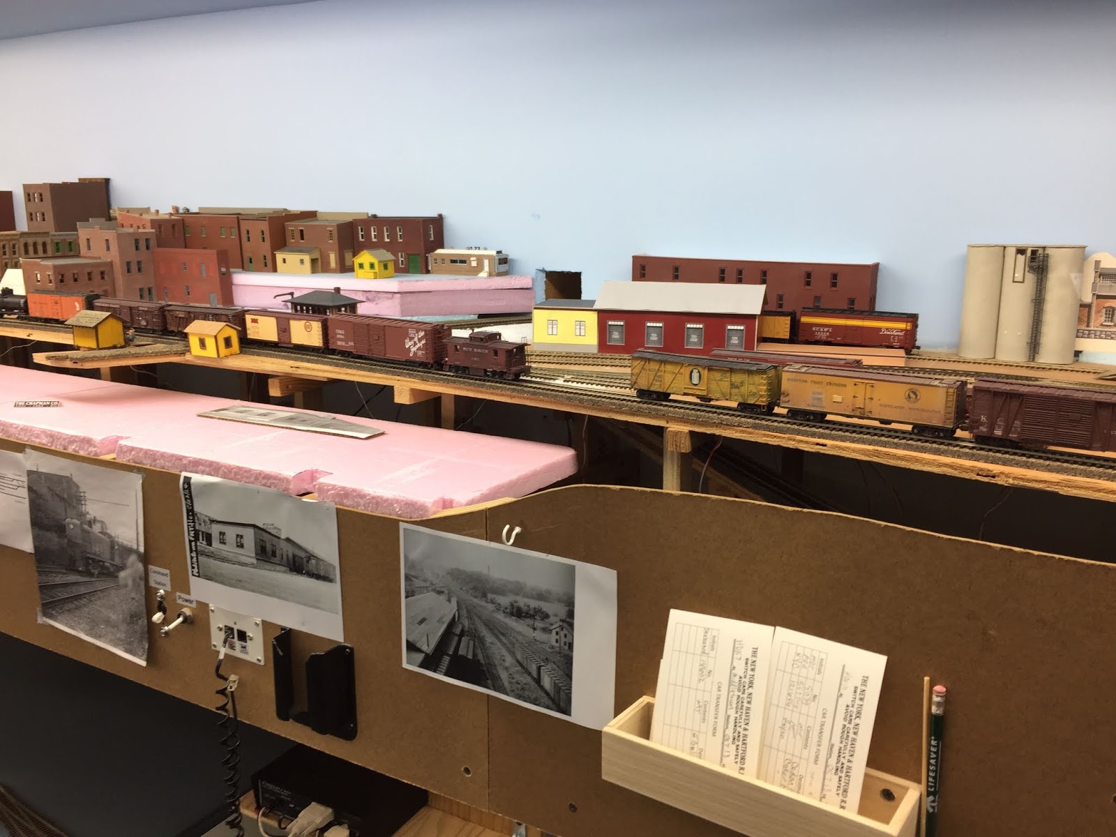
| Continuing south into Cromwell, this area - like so many during 2019 - gained a bunch of buildings courtesy Bill Maguire. |
 |
| Connecticut River lowlands area between Cromwell and Middletown - shot mostly in hopes this area will see big improvement in 2020. |
 |
| North end of Middletown |
 |
| Panning left toward the south, we see more of Middletown, including the Airline diamond. |
 |
| South end of Middletown. There'd be almost nothing here were it not for BillM. |
 |
| Continuing south, we see Davis Lumber with the old Hartford Rayon mockup in the background. |
 |
| And at the far south end of Middletown, we have the meat packing plant. The structure is actually an accurate model of the prototype Pratt & Reed Company, but I've repurposed it here. It was the only place it'd fit and there was no way I wasn't going to use it! |
 |
| Further south of Middletown, we cross the scenic highlight of the line - the high bridge in the Shailerville section of Haddam. This scene (like Rocky Hill) courtesy Bill Schneider. |
 |
| Panning right (south) we see the hill at Camp Bethel. Per the prototype, there will be a couple of Methodist camp meeting cottages on top of the hill here. East Haddam is in the distance. |
 |
| "East Haddam and Moodus" - at least according to the sign that's at the station. You're looking southeast here and, one of these days, you'll see the CT River on the backdrop, along with a view of the 1913 swing bridge and Goodspeed Opera House on the other side. |
 |
| Panning right, we see Deep River on the other side of the (increasingly narrow) aisle. I have the fascia bump out temporarily mocked up to accommodate BillM's beautiful model of the lace factory - which here is situated close to where the prototype sits. Just have to see how my operators deal with the restricted space. |
 |
| Continuing south from Deep River, we head around the end of the peninsula towards Essex. |
 |
All these structures/bridges stored here are surplus - so let me know if you see anything you're interested in!
You can just start to make out Essex as we head south into town. |
 |
| Essex |
 |
| Comparing this scene to the same shot from last year, you can tell what a dramatic difference the Dickinson warehouse has made. |
 |
| Finally - the wye at Saybrook Junction and the famed NYNH&H Shoreline route. Scenery & structures courtesy BillS. |
 |
| Looking west along the Shoreline. |
 |
| The west end of the Shoreline (return loop) is now under the Air Line which is heading northeast (toward us) from Cedar Hill yard in New Haven. |
 |
| Looking northeast along the Air Line. |
 |
| Continuing northeast toward Middletown, the Air Line goes through the first of two fictional towns along the way. This is Somerset. |
 |
| Southwest view of the town of Somerset |
 |
| The second of two fictional towns along the Air Line - This is the south end of Mill Hollow. |
 |
| You can just about make out the entire town of Mill Hollow in this northeast view. |
 |
| Mill Hollow, looking west. |
 |
| Southwest view of Mill Hollow |
As I said, there's a lot of photos here, but I thought it'd be nice for you to see the layout in its entirety - warts and all. And it's especially nice for me to have a baseline against which to measure any progress I make in any of these areas during 2020.
Hopefully this time next year the "Layout Status" photos will look a lot different than they do today!


Thanks for the update tour of the layout. It is so beautiful. Really enjoy your regular project updates. Nice to have friends to help. All the best in 2020.
ReplyDeleteLooks great. Now, you just need to host a public open house!
ReplyDeleteAre you coming to the Springfield show?
Delete