So - this is Beckleys, a railroad station (more like a flag stop) on the Berlin Branch - in the town of Berlin, in fact. You're looking northeast. The track down to Middletown goes off to your right.

And this (Wordless Wednesday #52) is apparently a train heading into Beckleys. My best guess is that it's south/east bound and the station is behind us on the other side of the track.
In addition to the station, there was a siding to a milling company, back in the day. I'm just not sure when "back in the day" was on this particular map.
Interestingly, the view above - shot looking northwest - shows three tracks. Perhaps there was a passing siding there at some point? Looks like the milling co. siding is in the foreground.
So what of Beckleys? Apparently, according to the excellent website Tyler City Station (curated by friend - and Photo Librarian - Bob Belletzkie), the station was here primarily for a prominent Berlin family. Perhaps they even owned the milling company. Their name? Why, "Beckley" of course.
Here's a photo of the Beckley homestead with the "Mammoth Elm" on the right. The home was located north of the station, across the Mattabessett River (the river the train is likely crossing in the earlier picture).

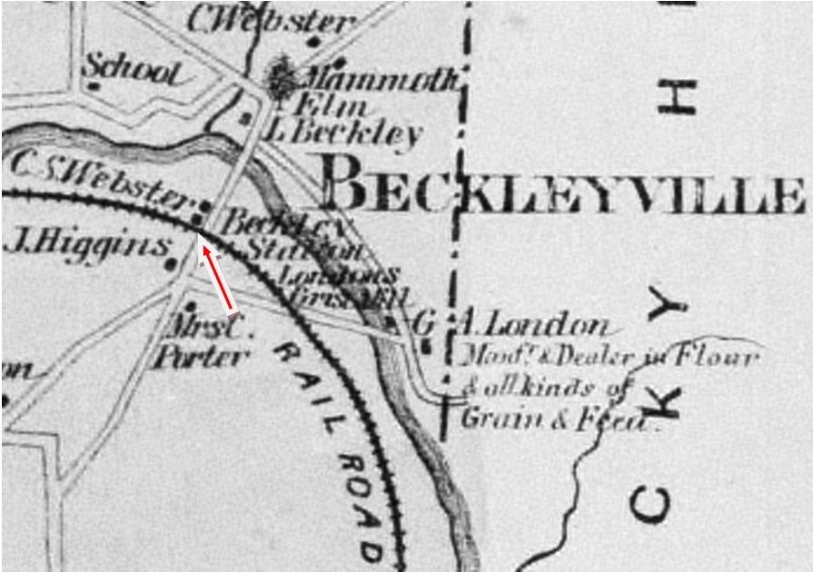
Also from Bob's website is this excellent period map that puts everything in perspective. The arrow points to where the station is. Go north across the river and you can see where the Beckley homestead and the "Mammoth Elm" were. Looks like Beckleyville was quite the place at one time.
But near as I can tell, most all of this is gone now. Though I was able to trace where all this likely was on a map from today:
You can see some echoes of the past here. I like Google Maps since you can often find the old RR ROWs if you know where to look (and zoom in far enough). On this map, you can barely make out the ROW coming up from the bottom and paralleling the river on its left. It curves into Wethersfield Rd and follow White Oak Dr. Other "ghosts" include the Beckley name, still hanging around in the area: Wethersfield Rd becomes Beckley Road as it goes south. And off Wethersfield Rd, just north of the river and near where the old homestead (and "Mammoth Elm") was, you can see Beckley Mill Road. Compare this map to the earlier map if you get lost.
I wonder what ever happened to the Beckleys. The old station - there, but dilapidated as recently as 1997 - is gone now.
More ghosts of the past. And more archaeology. It's amazing what you can see when you really look. And fortunately there are folks like BobB who've taken the time to assemble great information and share it with all of us. Be sure to check out his website if you have an interest in ANY New Haven Railroad related station - no matter how obscure. Most of what I know about Beckleys came from there.


No comments:
Post a Comment